 NIWA - Metadata Catalogue
Contact for the resource
NIWA National Institute of Water and Atmospheric Research
219 record(s)
Type of resources
Topics
Keywords
Contact for the resource
Provided by
Years
Representation types
Status
-
R/V Tangaroa
-
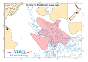
Multibeam data from the "Cook Strait Swath II" voyage (TAN0215) of the R/V Tangaroa. The voyage was the second dedicated and the fourth in total in an series used to build up an accurate map of the seabed morpholoy of the Cook Strait region. This voyage was concentrated in the southern Cook Strait region from Campbell Bank, over Nicholson Bank nd across to the Palliser shelf. Survey Leader: John Mitchell Organisations: NIWA Bathymetric Instrument: Simrad EM300 30kHz Multibeam Navigation Instrument: DGPS Ports: Wellington to Wellington
-
R/V Tangaroa
-
SMB Elaine
-

Multibeam data from the "Poverty Re-entrant" voyage (TAN0106) of the R/V Tangaroa. The voyage investigated the origin of the Poverty Re-entrant - a large margin re-entrant oalong the continental shelf off Povert Bay. It has been suggested that the Poverty Re-entrant was formed by the oblique impact of a large seamount and by massive and catastrophic avalanching of marhin rocks shattered by passage of the seamount through the margin but the original structure might be masked by later deposition, compressio, accretion of avalanche deposits, and erosion by canyons. Its structure may be further complicated by relatively recent seamount impacts. Survey Leader: Keith Lewis Organisations: NIWA Bathymetric Instrument: Simrad EM300 30kHz Multibeam Navigation Instrument: DGPS Ports: Wellington to Tauranga
-
Biophysical Moorings 1 survey undertaken by the R/V Tangaroa
-
OS2020 R/V Tangaroa
-
This voyage on the R/V Tangaroa was one of an ongoing series being used to build up an accurate map of the seabed morphology of the Cook Strait region, using the Simrad EM300 multibeam swath sounder The 100m contour was chosen as the nominal cutoff for data collection, with depths shallower than that giving too narrow a coverage.
-
The second of two voyages of the R/V Tangaroa to study the oceanography of the Macquarie Ridge. The voyage represented a collaboration between scientists and projects at NIWA and CSIRO Division of Marine and Atmospheric Research, the Antarctic Climate and Ecosystems Cooperative Research Centre (ACECRC), and the Research School of Earth Sciences, Australian National University (ANU) in Australia, and the Geological Nuclear Sciences Institute (GNS) in New Zealand. Voyage objectives: 1. Retrieve moorings deployed in 2007 in the gaps in the Macquarie Ridge 2. Undertake a physical oceanographic survey of the Macquarie Ridge 3. Collect sediment cores along the axis of the Macquarie Ridge and in the Emerald Basin 4. Survey the biodiversity and habitat of seamounts associated with the Macquarie Ridge 5. Deploy Argo floats
-
LIN06302 R/V Tangaroa