 NIWA - Metadata Catalogue
Creation year
2016
11 record(s)
Type of resources
Topics
Keywords
Contact for the resource
Provided by
Years
Formats
Representation types
Update frequencies
Status
-
A Marine Reserve is the government's most comprehensive tool in the provision of area-based biodiversity protection in the marine environment. Marine reserves are specified areas of the sea and foreshore that are managed to preserve them in their natural state as the habitat of marine life for scientific study. Marine reserves may be established in areas that contain underwater scenery, natural features, or marine life of such distinctive quality, or so typical, beautiful or unique that their continued preservation is in the national interest.Under the Marine Reserves Act 1971, the Department of Conservation isresponsible for caring for and managing marine reserves. Management functions include marking marine reserve boundaries, law enforcement, issuing scientific permits and monitoring environmental changes.
-
NZP&M - Spatial representation of all wells in New Zealand. Well header and bore information supplied by industry
-
NIWA's bathymetry model of New Zealand at a 250m resolution. The 2016 model is a compilation of data digitised from published coastal charts, digital soundings archive, navy collector sheets and digital multibeam data sourced from surveys by NIWA, LINZ, as well as international surveys by vessels from United States of America, France, Germany, Australia, and Japan. All data used is held at NIWA.Image service can be used for analysis in ArcGIS Desktop or ArcGIS Online - no need to download the data, just stream using this service and classify, symbolise, mask, extract or apply map algebra - just like you would with local raster files. https://enterprise.arcgis.com/en/server/latest/publish-services/windows/key-concepts-for-image-services.htmMap information and metadata Offshore representation was generated from digital bathymetry at a grid resolution of 250m. Sun illumination is from an azimuth of 315° and 45° above the horizon.Projection Mercator 41 (WGS84 datum). EPSG: 3994Scale 1:5,000,000 at 41°S. Not to be used for navigational purposes Bibliographic reference Mitchell, J.S., Mackay, K.A., Neil, H.L., Mackay, E.J., Pallentin, A., Notman P., 2012. Undersea New Zealand, 1:5,000,000. NIWA Chart, Miscellaneous Series No. 92Further Information: https://www.niwa.co.nz/our-science/oceans/bathymetry/further-informationLicence: https://www.niwa.co.nz/environmental-information/licences/niwa-open-data-licence-by-nn-nc-sa-version-1_________________________________________________________________________________________________________________Item Page Created: 2017-11-01 00:55 Item Page Last Modified: 2022-06-11 18:10Owner: NIWA_OpenData
-
The assessment comprised: Side-scan-sonar swath mapping of the site to characterise seabed topography and habitat types in the vicinity of the proposed extension. Photoquadrats of the seabed to ground-truth side-scan results and to further describe the seabed habitats in the vicinity of the proposed extension. Samples of large-bodied epifauna using a biologists sled, to aid in characterising the ecological features within the extension. Diver observations and core sampling of benthic organisms. Analysis of results and assessment of the ecological effects of the proposed extension. Consideration of the potential impact of farming new species including the molluscs blue mussel (Mytilus edulis), dredge oyster (Tiostrea chilensis), scallop (Pecten novaezelandiae), pacific oyster (Crassostrea gigas) and geoduck (Panopea zelandica), and the seaweeds Macrocystis pyrifera, Ecklonia radiata, Gracilaria and Pterocladia lucida. The seabed beneath the proposed extension was mainly gently sloping mud habitat with areas of sand/shell habitat and reef inshore of the proposed site. A dense population of burrowing shrimp (Upogebia hirtifrons) was also noted adjacent to the inshore boundary of the site. Such burrow systems are a biogenic habitat of ecological value. Scallops (Pecten novaezelandiae) were noted within the offshore portion of the proposed extension at densities estimated to be between 0.1 and 5 per m2 in patches.
-
Spatial representation of current petroleum permits in New Zealand
-
This archive contains data used in the manuscript Journal of Applied Ecology - 2015-00815.R1. Incorporating human behaviour into the risk-release relationship for invasion vectors: why targeting only the worst offenders can fail to reduce spread by Oliver Floerl; Graeme Inglis and Jan Diettrich. The study used an epidemiological model of recreational boaters to evaluate the efficacy of management campaigns aimed at reducing the spread of invasive biofouling organisms by improving antifouling behaviour. It examined the influence of three factors on the effectiveness of the campaigns: (i) the proportion of the vessel population that is targeted by the measure, (ii) the average amount of change in behaviour made by individual boaters, and (iii) the rate of uptake of the measure by the targeted population.
-
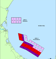
A proposed 5-yearly benthic monitoring plan was developed to satisfy the resource consent conditions for RM100973, that covers the thirteen 4 ha spat farms within subzone A, AMA1, in Golden Bay (Grange 2011). Subsequently, the Tasman District Council has modified the consent conditions for the 8 “consented” marine farms and is reviewing the 12 “Collingwood” farms in the same block. Accordingly, it seems sensible to combine the monitoring protocols and timing of surveys and reporting for all farms in the entire subzone. This short report is designed to confirm the approach detailed by Grange (2011), but to modify the sampling to cover the entire subzone A, not just the 13 spat sites. This report should be read in conjunction with Grange (2011), a copy of which is appended, to avoid repetition. (Grange, K.R. 2011. Monitoring programme, Golden Bay spat farms. NIWA Client Report NEL2011-016, prepared for Golden Bay Marine Farmers’ Consortium.10 p.) The monitoring plan includes a range of methods, including side-scan sonar, grabs, and drop camera/video images, and assessment of specified macro-invertebrates.
-
Occurrence data of five main species (Enallopsammia rostrata, Goniocorella dumosa, Madrepora oculata, Oculina virgosa, and Solenosmilia variabilis) of habitat-forming cold water corals in the New Zealand region.
-

Vulnerable marine ecosystems (VMEs) are ecosystems that are highly vulnerable to one or more kinds of fishing activity or other disturbance and are identified by the vulnerability of their components (e.g. habitats, communities or species). The South Pacific Regional Fisheries Management Organisation (SPRFMO) Convention includes specific provisions to protect VMEs. SPRFMO has defined ten benthic invertebrate taxa that are regarded as indicators of VMEs. They are: Porifera (sponges); Actiniaria (anemones); Alcyonacea (soft corals); Gorgonacea (sea fans); Pennatulacea (sea pens); Scleractinia (stony corals); Antipatharia (black corals); Stylasteridae (hydrocorals); Crinoidea (sea lilies); and Brisingida (armless stars). For management purposes, it is important to know where VMEs are known or likely to occur, based on the best available scientific and technical information. The likely presence of VMEs can be identified using habitat suitability models for indicator taxa, ideally across the entire SPRFMO area. This is the aim of the South Pacific VME project. Records of VME indicator taxa extracted for the SPRFMO area and the New Zealand EEZ from OBIS (Online Biogeographic Information System: www.iobis.org) together with other online data sources, and data from research institutes (e.g., NIWA, CSIRO) and fisheries agencies (e.g. MPI, AFMA) were used for the project. These data were compiled and groomed prior to use in the habitat suitability modelling. Data in this dataset represent records of the VME indicator taxa as extracted from the variety of data sources listed above and may include records that are outside of the SPRFMO area.
-
The ecology of subtidal rhodolith beds has been investigated for the first time in New Zealand, characterising two rhodolith species, Lithothamnion crispatum and Sporolithon durum, examining the structure and physical characteristics of beds at two locations and documenting their associated biodiversity. Site and characteristics: Field work was conducted in the Bay of Islands, at Kahuwhera Bay and Te Miko Reef, in February and September 2010. The rhodolith beds were mapped using a combination of techniques and the physical characteristics of the habitats were assessed and compared with adjacent areas outside the rhodolith beds. The rhodolith beds differed significantly in terms of water motion, sediment characteristics and light levels, with Te Miko Reef having characteristics regarded as typical of rhodolith assemblages, and Kahuwhera Bay being atypical with respect to sediments and water clarity. The Te Miko Reef bed was in clear water and rhodoliths were clearly visible sitting on top of the substrate in a more or less single layer over rhodolith- and shell-derived gravel, whereas at Kahuwhera Bay there were fine sediments suspended in the water column and covering rhodoliths and associated biota, and live rhodoliths were in a more or less single layer overlaying grey to blackened rhodoliths in a darkly coloured rhodolith/sediment sublayer. The two rhodolith beds differed in current direction and strength with no clear tidal signal or direction of water motion at Kahuwhera Bay and tidally driven water movement at Te Miko Reef with a dominant northwest flow.