 NIWA - Metadata Catalogue
Keyword
biodiversity
12 record(s)
Type of resources
Topics
Keywords
Contact for the resource
Provided by
Years
Representation types
Status
-
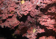
The ecology of subtidal rhodolith beds has been investigated for the first time in New Zealand, characterising two rhodolith species, Lithothamnion crispatum and Sporolithon durum, examining the structure and physical characteristics of beds at two locations and documenting their associated biodiversity. Site and characteristics: Field work was conducted in the Bay of Islands, at Kahuwhera Bay and Te Miko Reef, in February and September 2010. The rhodolith beds were mapped using a combination of techniques and the physical characteristics of the habitats were assessed and compared with adjacent areas outside the rhodolith beds. The rhodolith beds differed significantly in terms of water motion, sediment characteristics and light levels, with Te Miko Reef having characteristics regarded as typical of rhodolith assemblages, and Kahuwhera Bay being atypical with respect to sediments and water clarity. The Te Miko Reef bed was in clear water and rhodoliths were clearly visible sitting on top of the substrate in a more or less single layer over rhodolith- and shell-derived gravel, whereas at Kahuwhera Bay there were fine sediments suspended in the water column and covering rhodoliths and associated biota, and live rhodoliths were in a more or less single layer overlaying grey to blackened rhodoliths in a darkly coloured rhodolith/sediment sublayer. The two rhodolith beds differed in current direction and strength with no clear tidal signal or direction of water motion at Kahuwhera Bay and tidally driven water movement at Te Miko Reef with a dominant northwest flow.
-
Three specialist NIWA taxonomists collected algae, ascidians, and sponges in Sunday Cove from June 30 – July 3, 2014. This report is a comprehensive atlas for the algae, ascidians, and sponges of Sunday Cove. It is a live document that will be updated as new species are described and additional taxa such as bryozoans will be registered in Specify in the NIWA museum collection.
-
Taxonomic distinctness metrics calculated for selected benthic faunal groups across Chatham Rise and Challenger Plateau. Data were collected in 2007.
-
'Biotic habitat' classes derived from statistical classification of benthic fauna and substrate data across Chatham Rise and Challenger Plateau. Data collection occurred in 2007.
-
During 2006 and 2007, an ambitious project to quantify and characterise seabed habitats to depths of 1500 m on the Chatham Rise and the Challenger Plateau was carried out through a series of voyages, and subsequent analyses under the auspices of Ocean Survey 20/20, a long-term government programme to map the Exclusive Economic Zone. This report details the findings of Objective 10 which aimed to determine the biotic habitats on the seabed across the Challenger Plateau and Chatham Rise, assess their importance to ecosystem function, production, and sensitivity to disturbance. Available methods for determining the sensitivity of biotic habitats, biodiversity and benthic communities to physical disturbance of the seafloor were assessed, and overall patterns of sensitivity across the two locations described using 3 methods. Biotic habitats represent groups of taxa that occur at one or more sites. A number of taxa or a single taxon can define a biotic habitat. Sites within a biotic habitat may have faunal communities that are very similar to one another, or they may be quite different, making variable community composition a diagnostic of that biotic habitat. The 19 biological groups identified across sampling transects in the Chatham-Challenger project were confirmed as spatially contiguous biotic habitats, associated with specific environmental factors or found in specific locations. Of the 19 groups, nine formed major biotic habitats; one of which was unique to the Challenger Plateau and four unique to the Chatham Rise. The remaining ten groups formed minor biotic habitats, six of which were also unique to the Chatham Rise and one was unique to the Challenger Plateau. Biotic habitats are often associated with certain environmental characteristics (e.g., depth, slope) that make extended mapping possible through the use of these as surrogate variables. Here we were able to use depth, roughness, tidal currents and sea surface productivity as surrogate variables to produce maps of the biotic habitats across both the Challenger Plateau and Chatham Rise. Importantly, habitats are defined as covering scales of interest to a particular study or management objective, and in this case are broad-scale biotic habitats covering 10s – 100s of kilometres. The three methods used to define the sensitivity of benthic communities and biotic habitats differed in the way sensitivity was calculated: (1) the characterising and dominant taxa of a biotic habitat; (2) the abundance of all taxa at a site; or (3) the richness of all taxa at a site. The first of these methods is not recommended for use as it exhibited a low range of values. Methods 2 and 3 both showed wide ranges of values across both the Challenger Plateau and the Chatham Rise. They also produced low values where fishing intensity was high, as would be expected if sensitive species had been removed. Both these methods are likely to be useful as management tools for human-mediated physical disturbances such as bottom fishing.
-
The database contains all information obtained through global literature reviews, conversations, email and telephone enquiries about diseases of algae, with particular reference to diseases of the introduced kelp Undaria pinnatifida. Literature covered between 1891 and 2007.
-
To satisfy resource consent conditions for monitoring at 2 mussel farm sites in Pigeon Bay, Banks Peninsula, Pigeon Bay Aquaculture LTD commissioned NIWA to conduct a survey of the seabed beneath the 2 farm sites.Sampling for this project included a benthic grab, core samples and benthic dredge at sample sites established along 4 transects extending to the north, east, east(middle) and south of the farms. At each site, measurements and observations were performed to characterise key indicators of benthic effects including sediment grain size, sediment organic content, sediment smell and colour, depth of sediment, redox layer, infaunal community composition, epifaunal community composition, and shell drop. Results showed no evidence that the mussel farming activity had caused significant adverse impacts to the benthic habitat or communities beyond and beneath farm boundaries.
-
To satisfy resource consent conditions for monitoring at 2 adjacent mussel farm sites in Port Levy, Sanford LTD commissioned NIWA to conduct a benthic monitoring survey using methods detailed in the resource consent. Sampling for this project included a benthic grab and benthic sled to obtain samples to describe sediment physicochemical characteristics, and benthic assemblages at sample sites established along transects extending to the northwest, north and east of the farm block. Results showed no evidence that the mussel farming activity had caused significant impacts to the benthic habitat or communities beyond farm boundaries.
-
A range of univariate metrics describing benthic faunal biodiversity across Chatham Rise and Challenger Plateau. Data were collected in 2007.
-
This report presents diversity metrics of benthic organisms between and within the Chatham Rise and the Challenger Plateau areas sampled during Ocean Survey 20/20 voyages to the area in March-April and May-June 2007. The Ocean Survey 20/20 voyages represent the most comprehensive sampling initiative in these areas to date and aimed to describe patterns of benthic habitat and biological diversity across extensive areas of the EEZ. Objective 6 (addressed in this report) was devised to provide information about the biodiversity of the Chatham Rise and Challenger Plateau; compare many of the different indices of biodiversity available; and analyse how these vary across a range of spatial scales and taxonomic resolutions.