 NIWA - Metadata Catalogue
Keyword
multibeam bathymetry swath seafloor marine geophysics
34 record(s)
Type of resources
Topics
Keywords
Contact for the resource
Provided by
Years
Representation types
Status
-
OS2020 R/V Tangaroa
-
Multibeam data from New Zealands International Polar Year - Census of Antarctic Marine Life (IPY-CAML) project which incorporated a 55 day R/V Tangaroa voyage to the Ross Sea region in February-March 2008. Multibeam data was collected using a Kongsberg EM300 echo sounder.
-
R/V Tangaroa
-
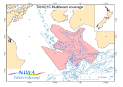
Multibeam data from the "Cook Strait Swath II" voyage (TAN0215) of the R/V Tangaroa. The voyage was the second dedicated and the fourth in total in an series used to build up an accurate map of the seabed morpholoy of the Cook Strait region. This voyage was concentrated in the southern Cook Strait region from Campbell Bank, over Nicholson Bank nd across to the Palliser shelf. Survey Leader: John Mitchell Organisations: NIWA Bathymetric Instrument: Simrad EM300 30kHz Multibeam Navigation Instrument: DGPS Ports: Wellington to Wellington
-
This voyage on the R/V Tangaroa was one of an ongoing series being used to build up an accurate map of the seabed morphology of the Cook Strait region, using the Simrad EM300 multibeam swath sounder The 100m contour was chosen as the nominal cutoff for data collection, with depths shallower than that giving too narrow a coverage.
-
MARGINS R/V Tangaroa
-
R/V Tangaroa
-
OS2020 R/V Tangaroa
-

Multibeam data from the "Wanganui Neotectonics - Back-arc Extension" voyage (TAN0105) of the R/V Tangaroa. Multibeam data was acquired on the Narrows Basin of Cook Strait as part of this voyage. The voyage was undertaken as part of the "Extensional Back-arc Processes" project of the "Active Seabed Processes" FRST programme. The objectives of the programme are to determine the contemporaneous processes of extensional faulting, subsidence and sedimentation in the Wanganui Bight and Bay of Plenty, to compare the mechanisims of extension, potential seismicity of offshore faluts, and the influence of sealevel cycles on sediment-tectonic interactions at opposite ends of the back-arc region of the Hikurangi subduction zone. Survey Leader: Geoffroy Lamrache Organisations: NIWA Bathymetric Instrument: Simrad EM300 30kHz Multibeam Navigation Instrument: DGPS Ports: Wellington to Wellington
-
This voyage of the R/V Tangaroa had multiple objectives: 1. deployment of 45 Argo floats on behalf of the School of Oceanography, University of Washington 2. deployment of 5 floating Met bous for the New Zealand MetService 3. accurately survey basepoints on the Bounty and Antipodes Islands groups 4. hydrographic surveying of the seafloor around the Bounty and Antipodes Island groups (CSP 2005 MS9-BA)