 NIWA - Metadata Catalogue
Creation year
22/0
3 record(s)
Type of resources
Topics
Keywords
Contact for the resource
Provided by
Years
Representation types
Status
From
1
-
3
/
3
-
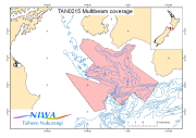
Multibeam data from the "Cook Strait Swath II" voyage (TAN0215) of the R/V Tangaroa. The voyage was the second dedicated and the fourth in total in an series used to build up an accurate map of the seabed morpholoy of the Cook Strait region. This voyage was concentrated in the southern Cook Strait region from Campbell Bank, over Nicholson Bank nd across to the Palliser shelf. Survey Leader: John Mitchell Organisations: NIWA Bathymetric Instrument: Simrad EM300 30kHz Multibeam Navigation Instrument: DGPS Ports: Wellington to Wellington
-
MARGINZ R/V Tangaroa
-
MARGINZ R/V Tangaroa