 NIWA - Metadata Catalogue
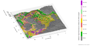
NIWA A-Y surface sediment data standardised dbseabed format
NIWA surface sediment data from the NZOI A-Y stations that have been standardised to the dbseabed format. NIWA samples have been processed and QC'd by INSTAAR University of Colorado, Boulder.
dbSEABED creates unified, detailed mappings of the materials that make the seafloor by efficiently integrating thousands of individual datasets. The goal is to bring decades of seabed information - and today's information - from marine geology, biology, engineering and surveys into one seabed mapping that can fulfil the community needs for ocean-bottom information on many spatial scales. The system deals with seabed texture, composition, acoustic properties, colour, geology and biology.
Quality assurance is achieved by checks on data at data entry, by error-trapping in the data-processing software, and by working the data intensively in various collaborative research programs. dbSEABED was devised to be robust in an inexact and incomplete information environment - marine geosciences.
There are two versions of the data available:
(1) the archives data, which are available as MS Excel spreadsheets - one for each letter of the A-Z station registers;
(2) NIWA nzSeabed standard data, which is the same standard afters being standardised by dbSeabed and are available as ASCII text files.
The data are available at either
Q:\Ocean_Geology\Sediment%20samples/ or file://niwa.local/groups/wellington/Ocean_Geology/Sediment%20samples/
|
|
Citation proposal
. . https://dc.niwa.co.nz:/niwa_dc/srv/api/records/cd65ed69-ca0c-91ab-6ee0-98eab9a65dfc |
- Identification
- Content
- Distribution
- Quality
- Lineage
- Spatial rep.
- Ref. system
- Acquisition info
- Metadata
- Portrayal
- Md. constraints
- Md. maintenance
- Schema info
Identification
Data identification
Citation
- Date ( Creation )
- 2015-02-10
- Date ( Revision )
- Purpose
- These data are appropriate for plotting and further analyses.
- Credit
- Helen Bostock, Kevin Mackay, Chris Jenkins (INSTAAR)
- Status
- Completed
Principal investigator
NIWA
coInvestigator
NIWA
- Spatial representation type
- Text, table
- Topic category
-
- Oceans
Extent
- Description
- New Zealand Region
coordinates
No information provided.
N
S
E
W
))
TimePeriod
beginPosition
No information provided.
endPosition
No information provided.
-
- sediment analysis, seafloor
Legal constraints
Text
No information provided.
Text
No information provided.
Security constraints
Text
No information provided.
- Classification
- Restricted
Locale
- Language
- English
Character encoding
No information provided.
Distribution
Digital transfer options
Lineage
Lineage
Text
No information provided.
Scope
- Hierarchy level
- Dataset
Text
No information provided.
Ref. system
Reference system
No information provided.
- Reference system identifier
- OGP / urn:ogc:def:crs:EPSG::4326
- Reference system identifier
- NZST/NZDT
Metadata
mdb:MD_Metadata
- Metadata identifier
- cd65ed69-ca0c-91ab-6ee0-98eab9a65dfc
Locale
- Language
- English
- Character encoding
- UTF8
Custodian
NIWA National Institute of Water and Atmospheric Research
301 Evans Bay Parade
Hataitai
Wellington
6021
New Zealand
Hierarchy level
- Resource scope
- Dataset
Text
No information provided.
- Date info ( Creation )
- 2015-05-12T09:09:37
- Title
- ISO 19115-3
Md. constraints
Security constraints
Text
No information provided.
- Classification
- Restricted
Overviews
thumbnail

large_thumbnail
Provided by

Views
cd65ed69-ca0c-91ab-6ee0-98eab9a65dfc
Access to the portal
Read here the full details and access to the data.
Associated resources
Not available