 NIWA - Metadata Catalogue
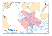
TAN0215 : Cook Strait Swath II - Multibeam Bathymetry
Multibeam data from the "Cook Strait Swath II" voyage (TAN0215) of the R/V Tangaroa.
The voyage was the second dedicated and the fourth in total in an series used to build up an accurate map of the seabed morpholoy of the Cook Strait region. This voyage was concentrated in the southern Cook Strait region from Campbell Bank, over Nicholson Bank nd across to the Palliser shelf.
Survey Leader: John Mitchell
Organisations: NIWA
Bathymetric Instrument: Simrad EM300 30kHz Multibeam
Navigation Instrument: DGPS
Ports: Wellington to Wellington
|
|
Citation proposal
. . https://dc.niwa.co.nz:/niwa_dc/srv/api/records/00003320-w9k1-smrs-yv8c-4ljdg8s0po1c |
Simple
- Date ( Creation )
- 22/01/03
- Date ( Revision )
- 22/01/03
- Purpose
- Research
- Status
- Completed
Point of contact
- Spatial representation type
- Vector
- Topic category
-
- Oceans
- Geoscientific information
- Elevation
N
S
E
W
))
-
- multibeam bathymetry swath seafloor marine geophysics
- Use limitation
- Not to be used for navigation
- Language
- English
- Character encoding
- UTF8
mdb:MD_Metadata
- Metadata identifier
- 00003320-w9k1-smrs-yv8c-4ljdg8s0po1c
- Language
- English
- Character encoding
- UTF8
Point of contact
NIWA National Institute of Water and Atmospheric Research
301 Evans Bay Parade
Hataitai
Wellington
6021
New Zealand
- Resource scope
- Dataset
- Date info ( Creation )
- 09/05/11 08:45:34.899655 +12:00
- Title
- ISO 19115-3
Overviews
thumbnail

large_thumbnail
Provided by

Views
00003320-w9k1-smrs-yv8c-4ljdg8s0po1c
Access to the portal
Read here the full details and access to the data.
Associated resources
Not available